Category Archives: FAQ

My GPS stopped working

This article has been superseded by this new and expanded version.

GPS signal is tricky: it’s affected by the quality of the phone (the Samsung Galaxy S had notoriously bad GPS reception) and by the environment it’s in (indoors, urban canyons or dense forest reduce the quality of the GPS signal).

However, all other parameters being equal, if your GPS suddenly seems much worse (the GPS arrow no longer appears even if you’re moving faster than 5km/h, MyTrails no longer reports the speed, or the GPS signal quality meter remains red), you may need to reset your GPS.

MyTrails doesn’t do this for you, but you can install the GPS Test app, go into its settings and tap the Clear AGPS, then Update AGPS buttons.

One some devices, setting the Temporal resolution to a value greater than 1s (in MyTrails > Preferences > Behavior) causes the device to stop updating the GPS. This is a bug on your device, and you can work around it by setting the temporal resolution back to its default of 1s.

Some devices disable the GPS when the battery is low. Some Kyocera phones for example, disable it below 20% battery, without any visible indications. This may be configurable in the phone’s battery saving settings.

I deleted a premium map from my phone, how do I get the credits back?

Most premium maps sold via MyTrails are priced according to how much of the map you wish to store on your device. Within that limit, you can download the parts of the map you wish, and when you no longer need a given area, you can delete it and download a different area.

Because MyTrails allows you to use the map on different devices, just deleting the map on one device is not enough, the map needs to be unregistered on the server.

When you try to delete a an offline map you have created from a premium map, MyTrails asks whether you want to just delete the map locally (presumably it can still be used on another device) or also unregister it.

You only get the download credits back if you unregister the map. Even then, you may not get back the exact amount of credits corresponding to the area of the offline map you unregister: MyTrails keeps track of the area of all your offline maps, and computes the total area, excluding overlaps (the area of the union of your maps), which means that if the map you unregister overlaps another map, the overlapping area will not be refunded.

What happens if you make a mistake and omit to unregister it? You need to use our server to unregister it.

  1. if you do not yet have a FrogSparks account, create one from your device: MyTrails > Preferences > Accounts > FrogSparks > Register, which will associate the maps you have purchased from your device with your account.
  2. from your device or a computer, go to our self-administration server.
  3. once you’ve logged in, you’ll see the list of offline maps you have created, and you can unregister the map.

Hidden options

MyTrails uses a trick for some hidden options that are not useful for most users, but which we may ask you to use when tracking down an issue.

To use these options, you need to run MyTrails, then select menu > Look for > address or location (on tablets, you can use the search field at the top of the screen) and enter the hidden option name exactly as indicated, all in lower-case and without extra spaces, then run the search. Most options will confirm the action with a toast notification.

  • toggle fake tracker: uses a simulated GPS tracker rather than the actual GPS
  • jump fake tracker: makes the simulated GPS tracker jump (track break)
  • override bad mag sensor: uses relaxed checking for the magnetic sensor (some phones ship with a sensor that inaccurately reports its parameters, causing MyTrails to disregard it, this lets MyTrails use it anyway)
  • toggle no gps warning: MyTrails no longer warns when the GPS is switched off an official option is now available in the preferences
  • toggle tracker debug: turns on very verbose debug log for the tracker
  • toggle offline fallback: allows offline maps to use other offline maps as fallback (disabled by default because this makes it possible to create circular references) circular references are now handled dynamically
  • reset offline: causes MyTrails to look for offline maps, wiping its caches
  • reset no ask: resets the behavior of all those “and don’t ask again” dialogs an official option is now available in the preferences
  • dump all state: creates an email with all of MyTrails’ internal data, to send us so we can diagnose certain issues
  • benchmark: a basic benchmark of the map moving around and zooming; run it a few times in a row to make sure the caches are all set
  • set nad27 LOC, where LOC is a lower-case NAD27 location, such as canada, or western_us: sets the datum for UTM coordinates; to get back to using WGS84, use set nad27 none
  • screenshot: saves a screenshot (attempts to use 2048×2048 if there is enough memory, and goes down from there)
  • toggle logging system: alternates between standard Android logging, MyTrails logging and both; you can use that when reporting issues and Android logs are not informative (some devices have logging turned off)
  • toggle alternate distance: alternates between the standard Android way of computing distances and a work-around for phones affected by a rare Android bug. As of MyTrails 1.4.6, this has been promoted to an official preference (in Visual).
  • toggle random track color: by default MyTrails assigns a random color to new tracks (because the GPX format doesn’t specify a track color, if you load a GPX that was not created by MyTrails, it does not include a color); use this if you want all your tracks the same color.
  • toggle bigger mgm: create offline files with more tiles per file (1024 rather than 64) to better support huge number of tiles even on FAT filesystems (only useful to download entire countries at high zoom)
  • toggle volume zoom: if you don’t want MyTrails to capture your volume buttons, use this option.
  • export global waypoints: save your global waypoints to a GPX file (in /sdcard/MyTrails/global_waypoints.gpx) as a backup, which you can later import as a normal GPX (waypoints imported in this manner will not be global). MyTrails 2.0.3b4 and later.
  • toggle track filename display: in the Track manager track list, display the filename for each track rather than the name of the track as defined in the GPX (be aware that GPX files can contain multiple tracks, with different names). MyTrails 2.0.3 and later.
  • toggle check gps readings: allows MyTrails to record GPS points that are obviously not correct for hikers and bikers (by default, MyTrails rejects points with a speed greater than 200km/h).
  • toggle reverse volume zoom: reverse the zoom direction when using the volume buttons.
  • toggle reverse compass: fix the the rotation of the compass, when it seems reversed compared to the actual movement of the phone. Please remember to calibrate the compass before resorting to this.
  • set compass low pass [n]: filter the compass movement (15 is good value)
  • set kalman filter [n]: filter the GPS track (n: approximate nominal speed in m/s, for example 1 for walking, 8 for cycling)
  • toggle cert check: allow MyTrails to ignore failed certificate verification, which may happen on some versions of Android (including Blackberry)
  • toggle proximity wake screen: you can disable MyTrails turning the screen on for proximity notifications
  • toggle track mode: switch MyTrails’ track rendering between smooth triangles (the default), raw triangles and lines (a useful fallback for some display issues)

Enter the hidden option text in the search field

How can I plan a track?

In-application track planning is… planned for MyTrails 2.1. In the meantime, you can use the www.mytrails.com.au (My Trails) web site to plan a track on your computer, and import it into MyTrails. Note that the web site (My Trails) is developed and administered separately from the application (MyTrails, no space) and this web site.

  1. If you don’t already have an account on the My Trails web site, create one
  2. Log in to the My Trails site
  3. In the menu, select either Draw new trail (for freehand trail definitions, with the option to also snap to roads) or Navigate (to always snap the trail to what Google considers to be navigable)
  4. Create your trail and save it (on the Navigate page, you have the option of sending the trail via email directly to your device so you can open it straight into MyTrails)
    1. After saving the trail, you can view it in My Trails and email it to yourself.
  5. If you saved the trail rather than send it via email
    1. run MyTrails
    2. in Preferences > Accounts > My Trails, log in to your My Trails account
    3. open the Track Manager, then tap the Download button and select My Trails as the source
    4. the search function looks for tracks around a certain location (current GPS location, current map location or a waypoint): you may have to shift the map to the approximate location of the track first
  6. If you sent the trail via email, just open your email client on your device and open the attachment. MyTrails should be one of the applications that offers to open the document.

Why does my phone sometime stop recording the track?

In order to minimize battery impact on the device when recording a track while the screen is off, MyTrails uses the standard method offered by Android where the application is woken up by the OS only when a new track point is ready to be recorded.

The top reasons for this are:

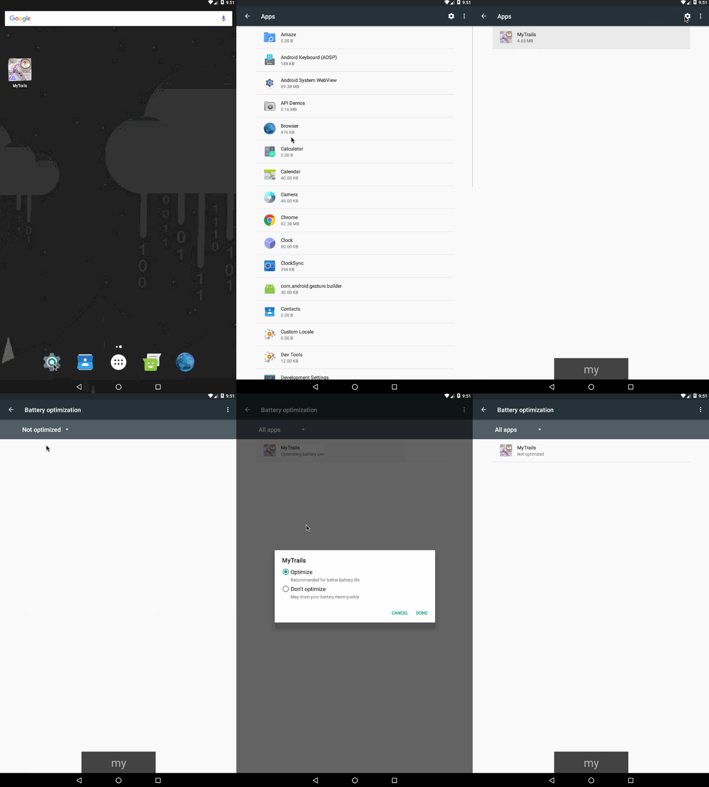
  • Android Marshmallow and later have the ability to stop background apps (to save battery) when the device is not moving. This shouldn’t affect MyTrails, except some versions of Android do this incorrectly and also stop apps when you’re hiking. In these cases, allowing MyTrails to keep running in the background may help: Android Settings > Apps > gear icon (Configure apps) > Battery optimization > All apps > MyTrails > Don’t optimize. Because this is a bit convoluted, I made short animation below.
  • Similarly, some customized Android versions such as Samsung’s include an Energy Saver feature that disables background GPS. Please check that it is disabled (it sometimes becomes enabled after a system update).
  • DontKillMyApp.com lists detailed steps to fix this for the various device manufacturers. Please check this first if you have this problem.
  • More info compiled by another GPS tracker app, Strava.

Other things you can try:

  • On some phones, Android may occasionally lose track of this, and forget to wake MyTrails up. This would result on a track where no recording takes place  during some stretches where the screen was off. Because this is a platform bug and so far has been reported only once, I do not intend to add a potentially harmful work-around to MyTrails.
    You can implement the work-around on your phone by downloading Wake Lock from the Play Store and using it to keep a PARTIAL_WAKE_LOCK when running MyTrails.
  • Some phones may incorrectly stop recording the track when the Temporal resolution preference in MyTrails is set to something other than 1s.
  • System optimizers such as Juice Defender may also stop the GPS when the screen is turned off. Disabling that dubious optimization restores the recording functionality.
  • Some devices disable the GPS when the battery is low.
  • Some users have reported that using GPS Test to clear and reload the AGPS data may help restore GPS operation for all apps.
  • GPS Locker helps prevent GPS from going to sleep on screen off.
  • Huawei phones running their Oreo ROM use extreme battery saving techniques, such that only keeping the screen on allows MyTrails to keep recording. Or maybe this page (in French but with Google Translate) may help.

If you do experience this and can’t fix it based on the solutions compiled here, please post in the forum so I can keep track of the affected users and phone models.

MyTrails complains my Pro license is outdated or that the license check failed

In some circumstances, MyTrails may be unable to verify the Pro license, and it displays an error dialog claiming that the license is outdated and needs to be updated from Android Market (Play Store). Until the license can be verified, Pro functionality will be disabled, which is usually very annoying.

In most cases, this isn’t really the problem (although you may check whether there is indeed an update), and what’s really happening is one of:

  • your device has been without a data connection for over a week, which has prevented Google’s licensing system from verifying the license status
  • Google’s servers have been having a bad day, and are not responding appropriately
  • something on your device is preventing the license check from happening

Things you can do to try to restore functionality (this is not a step-by-step recipe):

  • make sure you have a data connection
  • if you have an anti-virus or firewall app (AVG Mobilation has been reported to interfere with the licensing mechanism), disable it temporarily
  • if you use a battery optimization app, check that it didn’t disable data access for MyTrails Pro License
  • if you use a privacy management app, make sure that it doesn’t prevent MyTrails or the license from reading the Android ID, or at least that it presents the same made-up ID to both
  • uninstall and reinstall the MyTrails Pro License application (⚠ do not uninstall MyTrails itself, since in most cases your preferences and maps would be lost)
  • reboot your device
  • Go into MyTrails > Preferences > About MyTrails to check the Edition

If none of the above has the desired effect, please contact our support.

MyTrails 1.2.38 with the Pro license 1.0.4 should keep this kind of issues to a minimum, and the time constraints have been relaxed as much as possible.

My offline download pauses after 24h / I’m getting an error about a daily limit

Different map providers have different abuse-prevention mechanisms, but many limit tile downloads from a single device to 10,000 tiles per 24h period.

Even for premium maps (except IGN), such an abuse-prevention is used, and MyTrails will be able to download only 10,000 tiles per 24h period. The limit will be reset 24h after the first tile was downloaded, not 24h after the limit was reached.

Note that at latitude 45° for zoom level 15 (the zoom level used for 1:25,000), each tile covers about .8km², so 10,000 tiles represents about 8000km², so the most popular offline subscriptions can be entirely downloaded without hitting this limit.