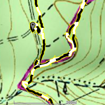
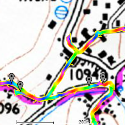
- New track rendering algorithm, much more eye-pleasing
- New Ordnance Survey map subscriptions (1/2 prices in some cases)
- Integration with Google account as a simpler alternative to FrogSparks account, where available
- The Pro license is now available as an in-app purchase tied to the FrogSparks (or Google) account, so it is honored on any platform
- Fixed HUD rendering on KitKat
Author Archives: frogsparks
Migration issues between FrogSparks and Google login
If you’re a new user, you should always use a Google login on the web site and on your devices (as long as you have configured a Google account on the device, which you have done if you use the Play Store or Gmail): it’s easier, one less password to remember, and you should not encounter any problem.
If you had already created a FrogSparks account, you should also migrate to using a Google account everywhere. In most cases, simply logging in to your Google account from MyTrails on a device that is also connected to your FrogSparks account should automatically merge your Google account to your FrogSparks account.
There is one possibility for failure: if your Google account’s email address is not the same as the email address you used for your FrogSparks account and you connect to your Google account from a device not already connected to your FrogSparks account, or from the web site, then both account will remain separate and you will not be able to merge them. You should contact us so we can delete your Google account from our databases so you can then merge the account properly as described above.
You may choose to use only a FrogSparks account everywhere (if you don’t have a Google account for example). Or once you have an account that works both as a Google account and a FrogSparks account, you can use the FrogSparks account where the Google login is not available (for example on Kindles).
A few new maps
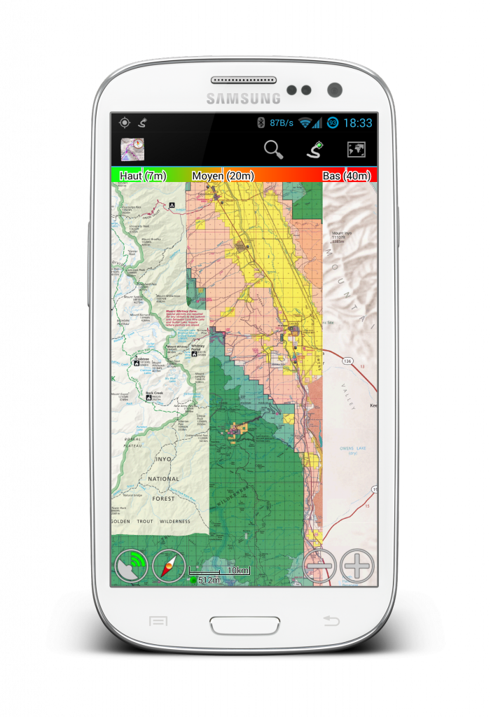
With the latest beta of MyTrails, add a map configuration by just clicking a specially-formatted link. Here’s a short list of maps to explore:
- SwissTopo (Switzerland)
SwissTopo(Switzerland)SwissTopo(Switzerland)SwissTopo(Switzerland)SwissTopo(Switzerland)- National Geographic World map (US and world for low zoom levels)
- Some amazing maps from CalTopo (US – most of these maps are not available everywhere even in the US; if the map doesn’t load, zoom out and try to move around)
- Contour and altitude shading (US); combine these with the above using layer maps or update the URL map to include both maps, separated by a
||(double pipe)- Shaded Relief
- 40′ Contours
- Fixed Slope Shading
- Gradient Slope Shading
- Example combined map: 7.5′ Topo Maps with Shaded relief (importing this map works in MyTrails 1.4.1b1 and later, and requires that you first import Shaded Relief and USGS 7.5′ Topo Maps)
- HEMA Road Atlas (US)
- USFS (US, world)
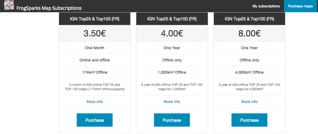
Buy maps directly on our website at a discount!
It’s no secret Google took their cue from Apple when they designed the pricing structure for app purchases (and in-app purchases): like them they keep 30% of any and all sales, with the developer getting the remaining 70%.
This is fair for apps; after all they offer exposure, easy and integrated payment, and the greatest platform there is (hmm, does he mean Apple or Google is the greatest platform, or both?). And since 75% of paid apps on the Play Store are sold for less than $2.50, the fact that Google keeps close to a third of it doesn’t matter much.
For in-app purchases, especially fairly expensive ones, it does matter a bit more! So I’m happy to report that you can now purchase maps at a discount when you get them directly on our site.
We use Google Wallet for payment, and since that’s the same back-end Google uses for the Play Store, if you’ve ever bought an app or made an in-app purchase on Android, your account should be already set up.
Coupled with the upcoming MyTrails integration with Google accounts, this should make buying maps a snap. And about 10% cheaper than IAPs. The prices listed on our topo maps pages remain the IAP prices, and you can click through for the direct price.
At the moment, the prices indicated on our storefront are in Euros, but once you click the Purchase button, Wallet should translate that into Pounds pronto.
We’ve also taken the opportunity to redesign the account page to make it less ugly. Please let us know if we missed or broke something!
Using Ordnance Survey maps? MyTrails needs you!
Update: Ordnance Survey maps are no longer available for sale in MyTrails
If you have a current subscription, you can use it until it runs out, but you won’t be able to renew it.
On new installs of MyTrails, OS maps are not defined by default, so if you reinstall MyTrails and you do have a subscription, you can add the map by going into MyTrails > Preferences > Map Manager and tap Add, then select the OS map you have a subscription for. You also need to be logged in to your FrogSparks account for the subscription to be recognized.
Read on for information about why this came about.
Three great pieces of news about Ordnance Survey

1. Price reduction on OS 25k
Ordnance Survey recently updated their pricing, and they are finally offering degressive pricing for offline maps (and at a much more reasonable price) for their 25k maps.
This is great news, as it makes it possible to keep all of UK 25k mapping offline for about 120£ per year (not that you need to, since with MyTrails you can exchange parts of offline maps you no longer need in exchange for other bits).
More realistically, it sharply reduces the price of the most popular offline subscription (4000km²) from £38 to £16.80.
In order to minimize the price as much as possible, I have split 50k maps apart, because the price of the 50k map is no longer negligible next to that of the 25k map. You can subscribe to both to create a hybrid offline in MyTrails.
If you’ve purchased a subscription since October 1st based on the old pricing and would like to take advantage of the new one, please send me the Wallet transaction number so I can cancel your order and you can purchase one of the new subscriptions.
Please note that Offline OS25k maps require MyTrails 1.4.0b3 or later.
2. Lifetime subscriptions are available
Previously, Ordnance Survey required that perpetually-licensed maps be downloadable only once (which I felt to be incompatible with MyTrails’ design philosophy), but now they offer a new lifetime license (in some locations, MyTrails also refers to it as a perpetual license), which does allow unlimited re-downloads, so MyTrails supports that.
It costs a bit over twice the yearly license, but you can use it as long as you like. It’s not quite like owning the map (because you can only use it with MyTrails – again, this is an Ordnance Survey requirement, not mine), but it’s as close as it gets this side of the digital divide.
3. OS has stopped one app that used OS maps without a license
Actually, this is good news for me (or should be, see below) or if you care about using officially-licensed maps…
In October, OS finally prevailed upon another Android app that was offering OS maps without a license (for free) to stop doing so. Since this application has way more users than MyTrails, this resulted in an uptick in the number of OS licenses I sold.
There is still another well-known app out there giving access to free OS maps… and that app is not free. If you look for it, you’ll find it :-).
More seriously, by all accounts these free OS maps are old (they’re still the same maps MyTrails used to offer in 2011, before Ordnance Survey asked me to stop and I switched to licensed maps) and they’re badly compressed and blurry. But people still use them because licensed maps are expensive, and I totally sympathize with that.
… And one not so great
There’s no easy way to say this, so here it is: Ordnance Survey requires a minimum yearly license revenue, and I’m not meeting it. Especially since they lowered their prices (which is great, did I mention that?).
This is where I need your help.
By early January 2014 I will have to stop selling OS maps, unless I can substantially increase my sales. So please talk to your hiker friend, your mtb buddy, the crazy climber dude who keeps threatening to rope you in. Tell them about MyTrails, about how irreplaceable OS maps are, and how you can do more with them when you use MyTrails.
And get them to treat themselves to a map subscription for Christmas.
If I have to cancel my Ordnance Survey license, your maps will not stop working. Online and offline map subscriptions will continue to work for the duration you paid for. You will still be able to exchange parts of your offline maps for new areas. But you will no longer be able to purchase additional OS map coverage to use with MyTrails, and I will no longer be able to update the maps to the latest OS data.
I can promise you that despite the fact that OS is more interested (legitimately) in the companies that have been selling tiny maps areas for £100 (and still are selling at over twice the price I am, after the price reductions), I will continue to work tirelessly to make MyTrails a great app for you.

Brand B pricing
And if I should have to cancel my OS contract, any OS map purchased between December 1st 2013 and January 15th 2014 will be reimbursed in full upon request.
So please head to our new storefront and help us keep our Ordnance Survey reseller license!
MyTrails Pro available as an in-app purchase
When I started developing MyTrails, in-app purchases (IAP) were not available on the Play Store, so like all apps from that generation, a tiny app (MyTrails Pro License) served to indicate to the main app that the user had purchased the Pro version.
It worked, for the most part, but some users didn’t know that they could just download the Pro license again for free when they switched to a new device.
So now MyTrails is available as an IAP. Buying it is slightly easier and the minor support burden should be a thing of the past.
I also wanted for users who have both a Google device and a Kindle to not have to purchase the Pro version twice just because of the platform divide, so the license information is stored on my server, and it is attached to your FrogSparks account.
On Google devices, the FrogSparks account is superseded by using your Google account; on Amazon devices the FrogSparks account remains. If you already have a FrogSparks account (or you also use a Kindle), both accounts can be attached by first connecting to your FrogSparks account, then your Google account, from your Google device.
All this happens in MyTrails > Preferences > Accounts > FrogSparks.
If you already have purchased the Pro license, MyTrails will first prompt you to create or connect to your account, and will transfer the license to the server, after which you will be prompted to uninstall the Pro License (but you don’t have to). The Pro License application will remain available on Google Play for the time being, but should no longer be used.
tl;dr: If you want MyTrails Pro, from now on the IAP is the way to go, MyTrails will guide you.
MyTrails available on Amazon Appstore
Many MyTrails users have a phone they take with them on outings, and they would like to be able to plan their itinerary and view the recorded track on their Kindle, which stays safely at home.
Until now, this was made more difficult by the fact that while MyTrails could be side-loaded on the Kindle, there was no good way to get the Pro version working on Kindle. And some people rely on Kindles exclusively.
So in a few days, once it passes Amazon’s validation process, MyTrails will be available on the Amazon Appstore, with the following changes:
- New track rendering algorithm, much more eye-pleasing
- Integration with Google account as a simpler alternative to FrogSparks account, where available (also log in to maps.frogsparks.com with your Google account)
- MyTrails is now available on Amazon Appstore
- The Pro license is now available as an in-app purchase
- Like maps, the Pro upgrade is tied to the FrogSparks (or Google) account, so it is honored on any platform
The same version will be published on the Play Store in a few days (I need to update a few Play-Store related things first, this is not an Amazon exclusivity period thing).
Update: MyTrails is now live on Amazon.
Nicer track rendering
One of MyTrails’ design principles has always been performance. I’m very proud of the fact that no other Android mapping application is as fast and smooth as MyTrails. This is partly because it uses OpenGL to render the map and tracks.
A big part of that is that MyTrails has to be able to display tens of tracks with thousands of track points without slowing down, and because of this, I have been hesitant to change the track rendering algorithm.
Things came to a head recently when I implemented the new Time and Distance colorizations. Suddenly (and especially in an emulator running on my low-pixel density computer display), the track looked very crude to me. And it’s always been: zoom out enough and it degenerates into a mess of horizontal and vertical hatches. Even up close, sharp edges in the track look broken. This is because OpenGL’s support for lines is very, very crude.
Also, it’s limited in terms of the thickness of lines it can draw (based on the GPU in each model of phone), and high-density screen in devices that use low-end GPUs (such as the Nexus 4) caused the tracks to be thinner than they should, and lack a border.
No more! In MyTrails 1.4.0, I’ve rewritten the track rendering algorithm, and lines are smoothly blended, can be rendered at any width, and are unbroken at any zoom level. And they’re still very fast (56 frames per second on a Galaxy S3, compared to 57fps for the previous algorithm).
During the beta period for 1.4.0, I will try to keep the hidden option ‘toggle track mode’ operational so you can compare the modes for yourself (there’s an intermediate mode that uses un-smoothed lines). If some phones are too slow for the new rendering mode, I can make it an official option for the release.
You can test the new rendering in MyTrails 2.0.0a6 and shortly in 1.4.0b1.
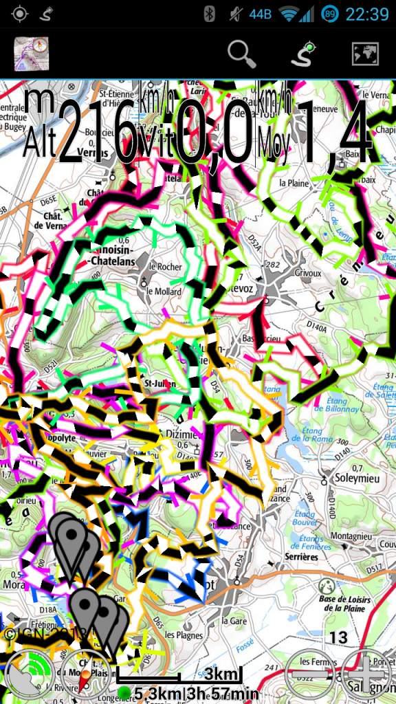
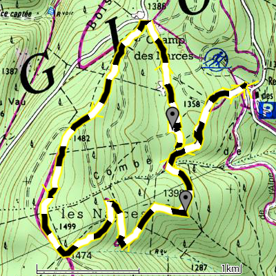
A few more screenshots to compare the old and new modes.
- Many new lines
- Old lines
- Smooth new lines
- Rough new lines
- Old lines
1.3.24-1.3.26
- New map: VTTrack-ST (single-track layer map)
- New colorizations: distance and time
- Layer maps can be taken off-line
- Show disabled GPS icon when no data is received from the GPS
- Screen lock no longer engages while using a dialog (only on Android 4.2 and later)
- File upload progress is more regular
- 2.1 work-around for IGN is no longer necessary
- GPSies: download your own private tracks
1.3.25 and 1.3.26 are bug-fix releases, sorry!
New colorizations: distance and time
In MyTrails 1.3.24 (currently in beta), I am very excited to add two new colorizations (or 4, depending how you look at them)!
How this came about was: one user wanted an easier way to figure out which way a track that circled back on itself came into and left the intersection. Playing with different possibilities, I realized that being able to visualize time and distance on the track (other than by looking at the speed visualization and performing differential math in our heads), would be useful.
I think my favorite is the distance colorization: it uses alternating black and white bands every 100m (100yd if you’re using imperial units), so you can very easily count the distance between two points on the track. It’s also easier than looking at the scale imagine twisting it along the track.
This only works if the track contains a high-enough density of points that MyTrails can alternate colors (which can happen only on a track point, not between points). Generated tracks (from a driving direction service, or by manually adding track points), or highly-simplified tracks (such as you may get from an online track sharing service) may not contain enough track points. Similarly, zooming out causes MyTrails to simplify the track and lose the ability to correctly represent the track.
Similarly, if you want to count how long it took to go from one point to another, the time colorization is very helpful. Each band corresponds to one-minute intervals.
The “rainbow” versions of these colorizations look silly, but they’re useful to try and follow the track through an intersection. Just keep in mind the sequence of colors, and follow along.
Unfortunately, when you look at these in MyTrails 1.3.24, they will not look as nice and smooth as these screenshots. This is because these were taken with an alpha version of 1.4.0, which I will tease more in another post soon!

